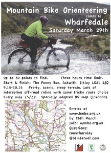
Tony Thornley has been hard at work planning our next event, all the details below.
Online entry here – closes Thursday 28th, discounts until Monday 24th
Registation 0900 – 1000 | Starts 0915 – 1015 | 3 hour course
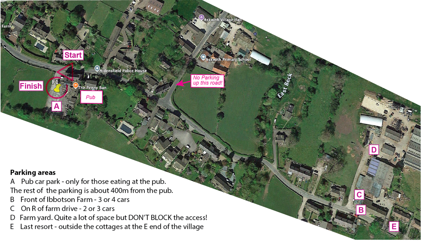
Important – Parking Registration is at the Penny Bun in Askwith, LS21 2JQ, which is also the finish.
Parking at the pub is limited; only those eating at the pub may use the pub car park.
Rob Marston at Ibbotson Farm has kindly agreed to let us park in his yard. It is ~400m E of the pub – see map below. If you park there, do not obstruct his access road. Do not park on the E-W road in the village unless there is nowhere else. If so, do not obstruct any residents’ entrances and only park on one side of the road. Registration will be at the back of the pub outside the pub door if fine or in the back of the pub if wet.
Toilets and food – there are toilets in the pub which should be open from 9.00. No muddy shoes/boots in the pub please. The pub has an excellent and extensive menu. There is no need to order food in advance; Gary the manager says he will be happy to cater for hungry bikers as long as they don’t all turn up at the same time. There is plenty of indoor seating as well as a lot of space outside if the weather is ok.
MapRun – the event is entirely MapRun based. b FAQ if you’ve not used it before. Don’t forget to download the event in advance (details to follow next week). All the controls have been checked for accuracy but GPS is variable. A Strava backup would be wise, but I’ll listen to pleading.
Start/Finish – You can register between 0900 – 1000 and start between 0915 – 1015. The time limit is 3 hours with the usual penalties. There are no pre-assigned start times; first come, first served. You will get control descriptions at registration. The start is on the road in front of the pub. MapRun will start if you tap ‘go to start’ at the pub. So, when told to start, and not before, tap ‘Go To Start’ on MapRun and it should bleep when the GPS finds you at the start. You will be timed from that point. The finish is in the pub car park. After finishing please report back to registration to confirm your finish: in the pub garden or in the pub if wet. I cannot see why anyone should cycle back past the start before they want to finish, but if you do MapRun might end your run. You can restart if near the start by repeating ‘Go To Start” and it will record it as a separate run. We will make adjustments at the end if anything goes wrong.
Course map – the blank course map is below. The map is 1:40000, adapted from the 50000 OS and is 350x275mm.This is a large and hilly area. I don’t think anyone will get near a full house of the controls, so choose carefully at the start. The map is marked with the usual 30 controls with points values between 5 and 30. Map size is almost A3: 350 x 275mm.
Important Safety!
- Kit: some of the routes cross high and exposed moorland. Come prepared if the weather is poor. We also urge you to wear a bright top and use lights as you are likely to use busy A roads.
- Some roads and routes are marked out of bounds with red crosses – don’t go there!.
- An unmanned, unsignalled level crossing in Burley in Wharfedale is usable, but be careful. Visibility is good and trains all warn of their approach.
- The Wharfe stepping stones in Burley in Wharfedale are usually under water. You will be told at registration if they are feasible on the day. If so, you cross at your own risk. They are out of bounds if I say they are uncrossable!
You must report to the finish. My phone number is on the map if you’re stuck.
However I am going to sing in Ilkley at about 1pm, so please ring Tim if stuck after then.
Terrain – It’s hilly. The rideability of the bridleways is shown on the map – see the legend – but these are weather and rider dependent. There is one short footpath at the E end of Danefield which you can use, but you must give way to any walkers you come across.
My phone: 07771843255. Tim’s phone: 07522 064419. Pub phone 01943 243200.u
Any other updates will be on here.
Hope to see you at the event!
Tony Thornley

Pingback: Askwith Start & Finish locations | nymbo : north yorkshire mountain bike orienteers