Registration: 9.15 – 10.15 Start Time between 9.30 – 10.30
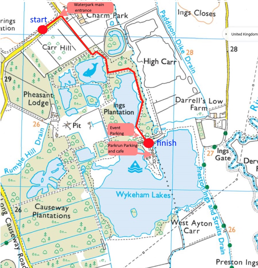
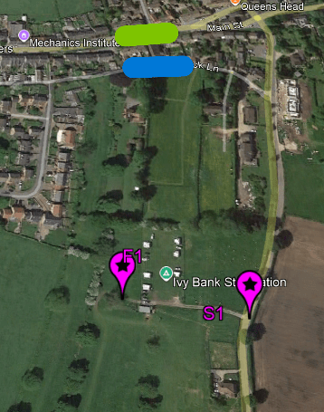
PARKING: Due to mud in the intended parking area we will now park further into the Waterpark near the finish and Café. We will park in the Zip Line carpark, you can’t miss this as you drive round the lake!! There are toilets at the Zip tower that we can use without crossing the parkrun course, and more toilets near the café. There will be an area cordoned off for our use however we will be sharing the car park with some park runners. There is plenty of parking. The start will now be an 800m ride to the entrance to the waterpark. Signs and marshals will be around to guide you.
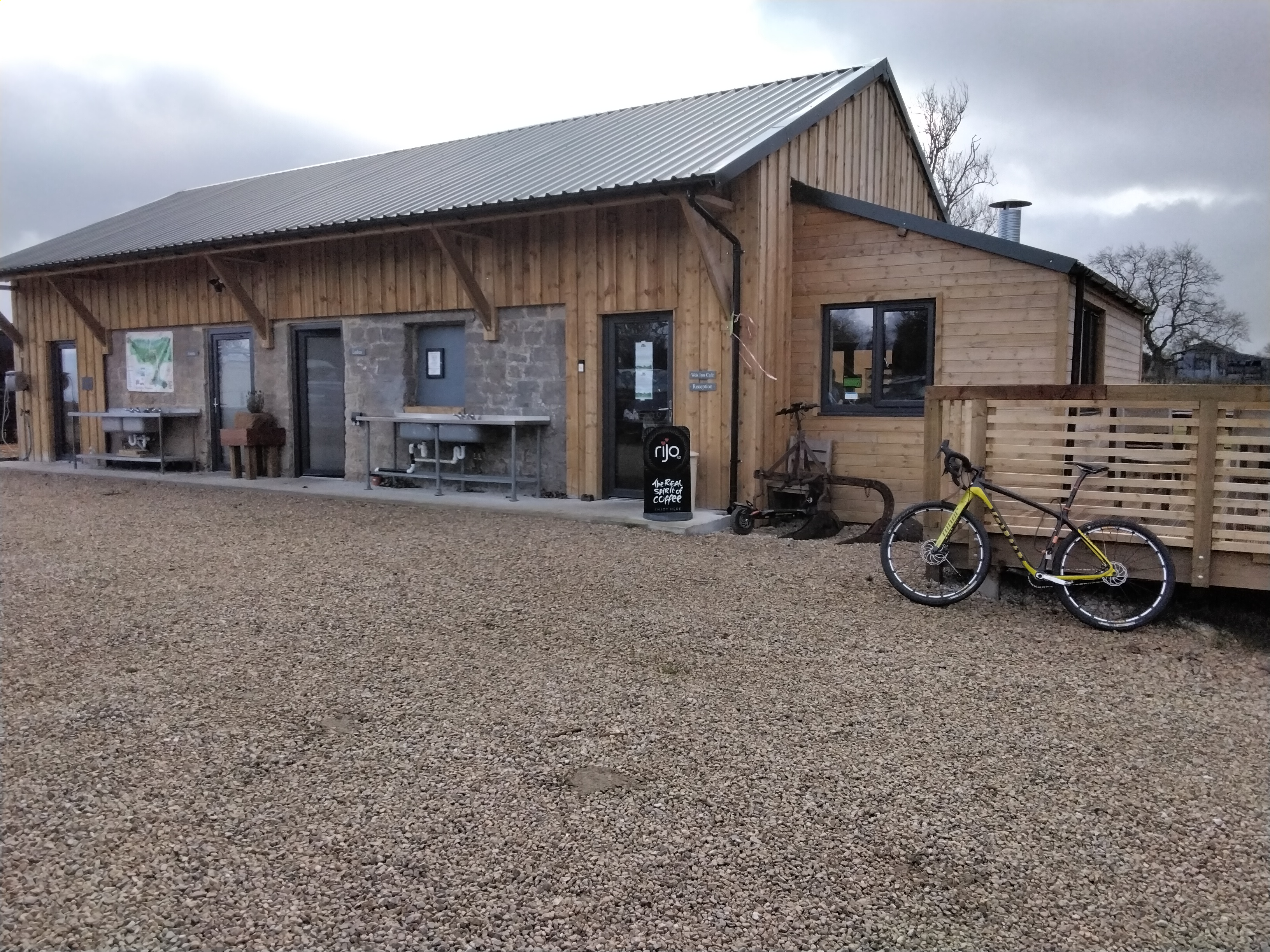
CAFE: This will be open from 9am if there are you are travelling with a non-rider. It’s busy with park runners from 9.30 -11.00 but will be quieter when riders are finishing. They serve pizzas, all day breakfasts and the usual café fair. They are happy to take orders for when you finish.
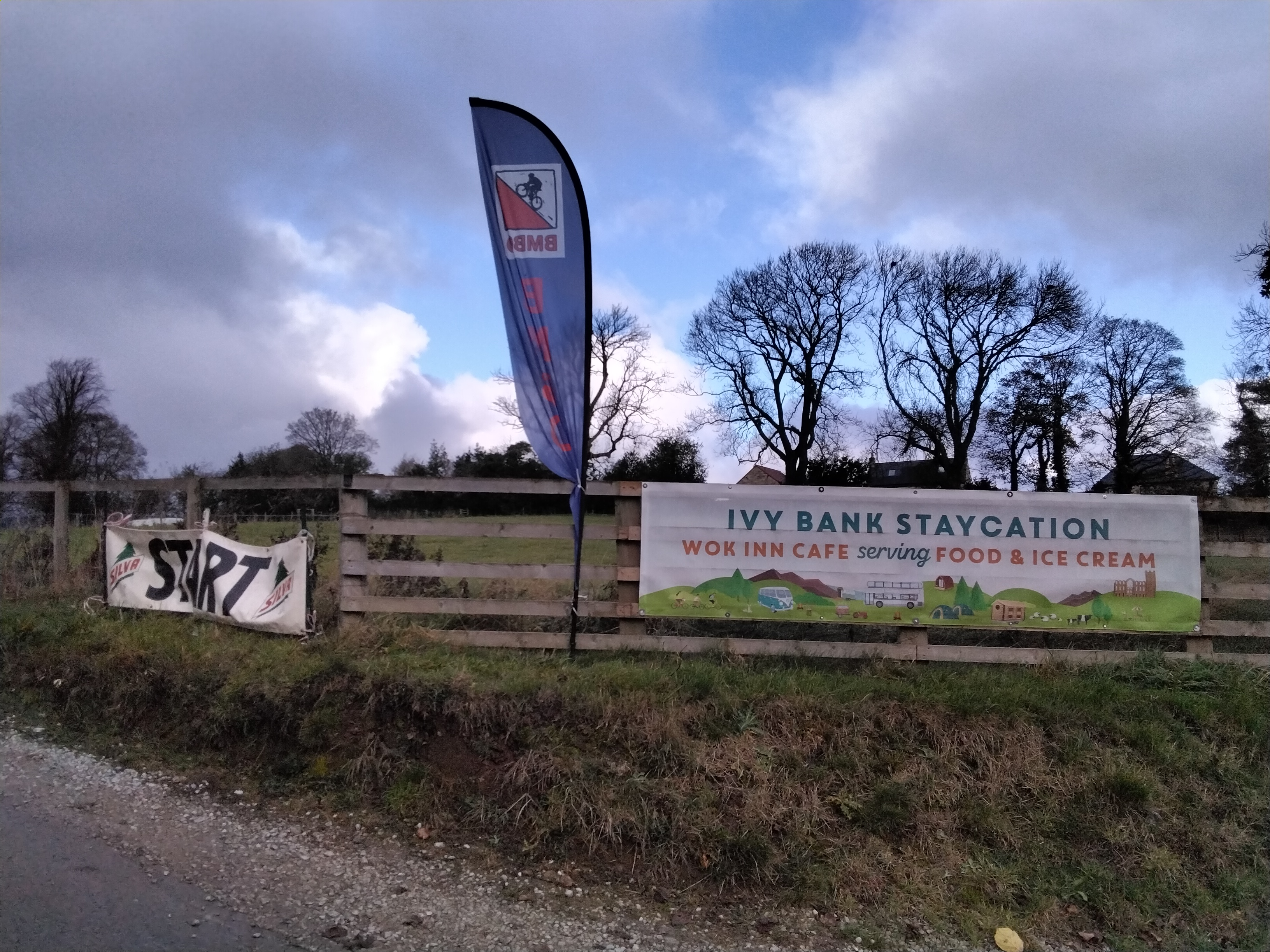
Just under 2 weeks until our next winter series event at the Yorkshire Water Park [insert joke here about most of Yorkshire being a water park at the moment]
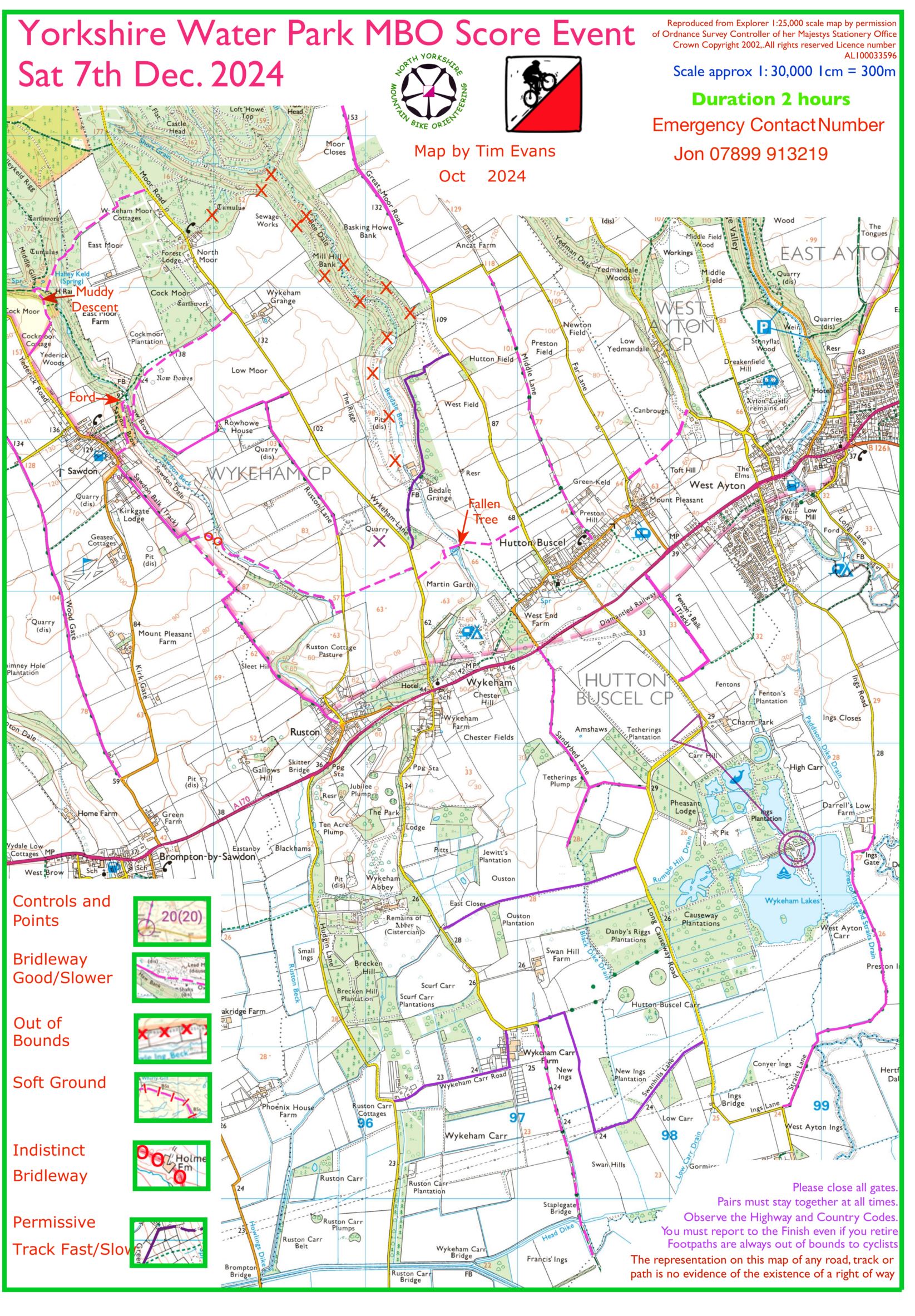
The event is based at North Yorkshire Water Park, Wykeham, Scarborough YO13 9QU. The site has plenty of parking, toilets, changing facilities and a large café. The course will be mostly based on the tracks and bridleways of the Wykeham estate and includes some paths not normally available to ride. There is one major A road (A170) that splits the course. The south of this road is flat and should be fast with a more challenging hillier section to the north of the road. Course map will be posted onlin at some point this week
Note: There is a regular Parkrun at the Waterpark on a Saturday morning that usually attracts 200+ runners. If you are feeling particularly energetic please feel free to arrive early and run this event.
Toilets: The main toilets are at the waterpark café. To access these you will have to cross the Parkrun course. This is easy but please dismount and follow the parkrun marshals directions. It is usually only busy between 9.20 and 9.40 so if you can avoid these times it would help.
Provisional results here (or find them in the MapRun app); corrections to Tim no later than Tuesday please so he can finalise and we can publish.
During the summer Dallowgill event, the centre manager mentioned the possibility of using Ivy Bank campsite as a bike O venue. Investigation revealed that it had parking, a small cafe, toilets, wifi & was a bit quirky [cut down beer barrels for gents urinals being one of them!] Add the free bike wash after, the decision was made. I biased the area to the E so as not to overlap the Dallowgill event, taking some of you on the BW E of the A6108 through Ripon Parks; in the S Studley Royal deer park showcased the rutting stags, impressing their ladies. Kirkby Malzeard has a lot of minor roads & gravel tracks, giving many route options without having to travel on the muddiest BWs. # 26 & 30 were temptingly located close to the finish but not all riders had time for them. # 14 & 28 were there to get you through Ripon whilst avoiding the town centre. The loop of # 5, 1, 6 seemed a good start but only scored 20 points – going straight to #11 scored 15 & took you to the same place much quicker.
The 47 riders enjoyed dry weather with virtually no wind, not bad for November but many were late back – a result of the lumpy contours & also the fact that Ivy Bank sits at the highest point on the course. When Andy Conn entered & then Edwyn O-Evans I was worried that the course may have been cleared in the 2 hour limit but not quite. Not too many tech problems, riders are obviously mastering the intricacies of MapRun, just a few phones misbehaving here & there; if you have a Garmin watch it can be loaded with the MapRun app via a phone or tablet, in my experience the watch is foolproof on these events.
Top rider was golden oldie M50 Andy Conn with 461, just ahead of M21 Edwyn 457, if only the latter had not been to Parkrun before perhaps he would have squeezed home. Local M50 Harvey Jones made use of his home advantage to score 449 once the young Rochesters had sorted his tech for him. Top Mix was Sally & Saul 324 just ahead of Claire & David’s 320 whose 70 penalties killed them. Solo ladies saw W60 Sarah Slade come out top with 310, head & shoulders above the rest; generation team result was close, the Dranes 316 just pipping the Risbey’s 310. Further down the field Pamela’s 279 was enough to see off partner Maurice’s 231 but he was concentrating on getting back to watch Leeds United that afternoon [why?]. Bad luck James LePage who suffered a puncture a couple of miles from home only to discover that his saddlebag had opened up & lost his repair kit, another rider did find his multi spanner though [small consolation].
Next event is Jonathan Purdy’s Yorkshire Water park at Wykeham [also an opportunity for Parkrun there first?] on 7 December – don’t miss this new area…. David Day Planner (thanks to David for organising an excellent course!)
There is still time to enter online for Saturday (until midnight Thursday). There might be enough maps for entry on the day, but please get in touch on Friday if you’re thinking of coming along.
Start and finish locations are below.
There are 2 road closures in Kirkby Malzeard village which will affect the event:
Back Lane south is currently closed to all traffic & impassable even to bikes – marked in blue
Main Street is also closed to traffic but bikes can get through on the pavements, please give way to pedestrians – marked in yellow/green
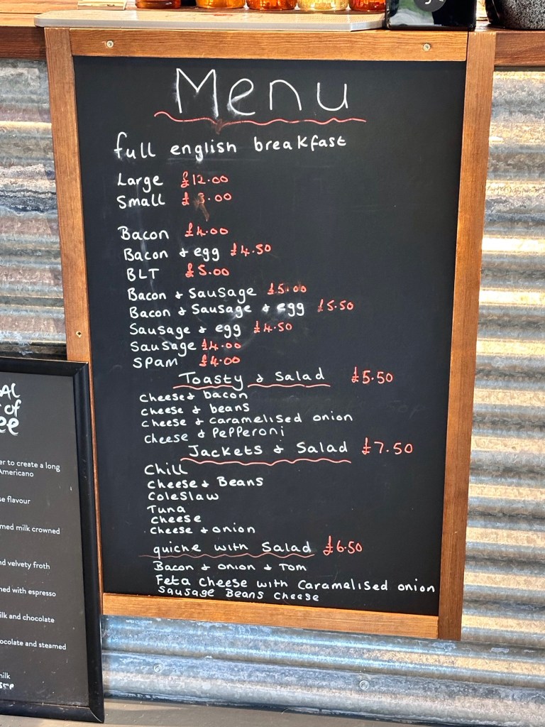
Cafe menu – suggest that you put your orders in before setting off on your ride to save time when you get back.
MapRun: course download is now ready, you can scan the QR code or by opening MapRun and follow select event / UK / North Yorkshire / NYMBO / Winter 24-25 / Kirkby Malzeard Nov 24
Start finish locations and road closuresYou can order lunch before you set off
Our next event is at Kirkby Malzeard on Saturday 9th November – online entry here
25% off entries by midnight on Monday 4th November
The 2 hour event will be based at Ivy Bank Campsite, Kirkby Malzeard, HG4 3SS. The site has parking toilets & a small cafe, start & finish are very close. Please support the venue by eating & drinking after the event.
The area is a myriad of minor roads, land rover tracks & bridleways [no need to ride the muddy ones], with controls mainly east of the start, avoiding the ground used for the Dallowgill event earlier this year. There are 2 major roads – A6108 & B6265 but the course will be planned to encourage riders to cross these at safe points.
Don’t forget to download the MapRun course before arrival (check back here for when it’s ready to download), please ask for guidance if you have not used MapRun before.
Registration: 9.00 – 10.00 Start Time between 9.30 – 10.30
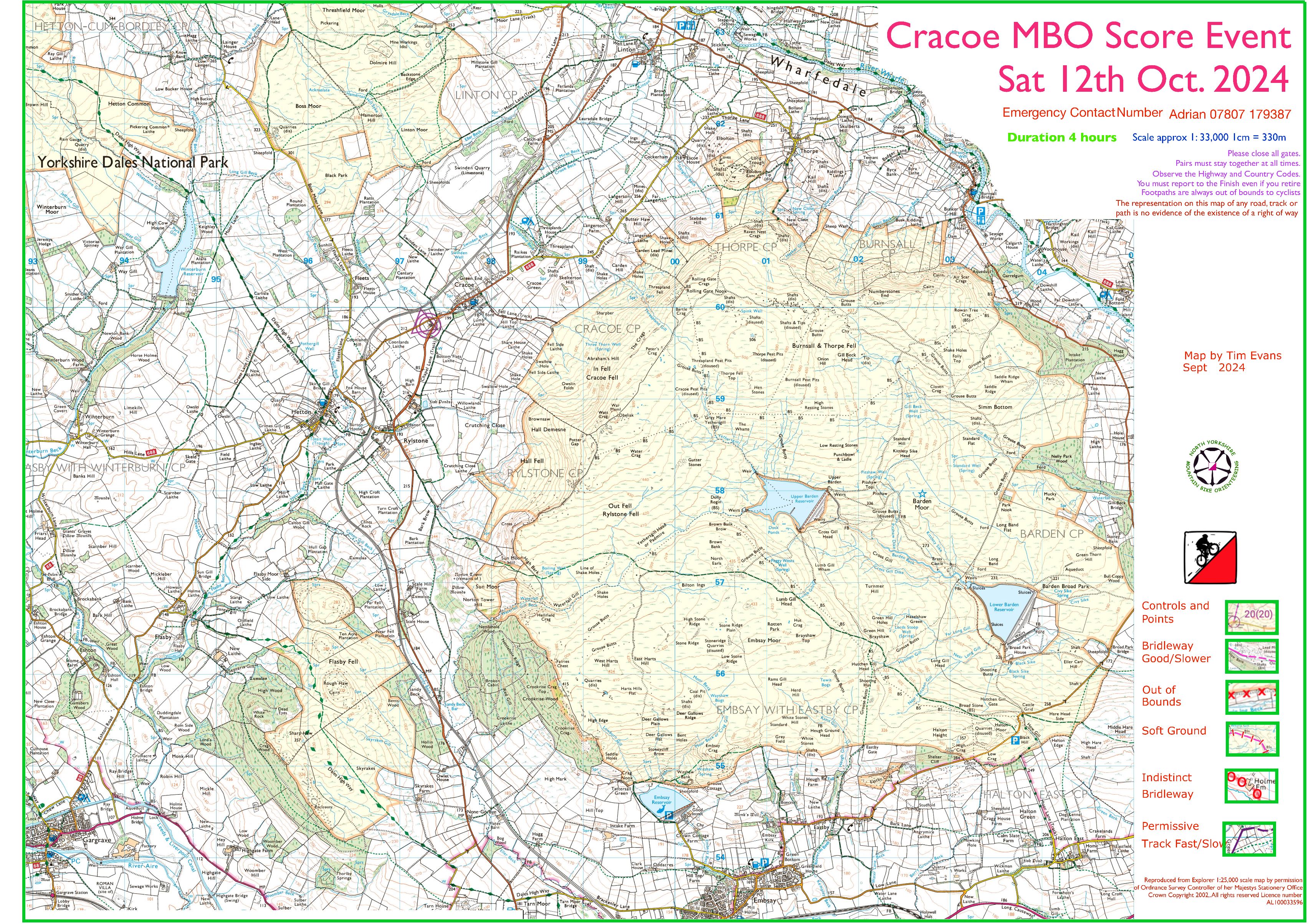
Adrian’s excellent event at Cracoe was a fitting finale to NYMBOs 2024 summer league. The final league can be found at the link below, it differs slightly from that on the day as we had the planners scores wrong, but it doesn’t impact on any prizes handed out.
This years prizes were included NYMBO cycling tops for the category winners; Dales Biking Centre vouchers and Yorkshire Dales Brewery Beer for the runners up.
If you rode 4 events or more this season then you quality for a NYMBO water bottle – please collect one at the your event if you didn’t get one at Cracoe!If you were lucky enough to receive a DBC voucher, please fill it in as follows (left blank dueto an adminerror😀):
To – Nymbo champion
From – S Willis or T Evans
Value – 2for1 Bunkhouse voucher
I hope you all enjoyed the series and numbers are starting to rise, I was worried about all the 4 hour events but it has allowed us to use better areas. Please spread the word about our events and how welcoming we all are (and if we aren’t please tell us!!).
I think the refreshments after the event seems to be encouraging you all to stay behind and chat and there is rarely any left over which is a good sign and encourages early starts.
Maprun seems to be working well for most of you. It makes life much easier for the planner and there are no controls to collect or get stolen, we also don’t seem to suffer as much from incorrect placement, if you are struggling with map run let us know we can set up short courses from your house or there are plenty of courses out there to try out.
Similarly if there is anything you would like to see or anything that annoys you let us know you may not be the only one and it may be something we hadn’t considered. As an example we think there may be an issue with some phones going to sleep after 30 minutes so we will try and avoid long legs that might take longer.
Thanks to all this years planners, Tony Thornley, John Dixon , David Day, Conrad and Jill Ellison, Steve Willis and Adrian Parker. Also thanks to Dave Robertson for all the comms and maintaining the website, Steve Willis for sorting the prizes and money, John Dixon for the league results, our sponsors Yorkshire Dales Brewery and Dales Bike Centre and all of you for entering and riding our events.
I look forward to seeing you at some the 4 winter events the first of which is the 9th November at Kirkby Malzeard.
We have 5 events with planners for next year but if you fancy having a go at planning and have an area in mind please talk to Steve or myself at an event or drop an email. You will be given lots of help and advice, it would be nice to go back to the Wolds.
Full 2024 league round-up with the prize winners to follow shortly. Thanks to Adrian for an excellent course, here’s his report:
46 riders and 45 finishers enjoyed(hopefully) the 4 hour event from Cracoe Village Hall. For all but the latest finishers the weather held out and there was the satisfaction of being warm and fed in the village hall at the series prize giving while the rain lashed down outside.
We had a number of debates before the event about the timings for it – originally starting at 3 hours and then toying with 3.45 hours (radical I know!) before settling on 4 hours. With the need to commit to the large loop over Barden Moor and Flasby Fell to score high we felt a shorter length event would lead to lots of late returns. We could have left in the escape route/more route choice by keeping the Skipton to Grassington road in bounds, but the road is fast, narrow, winding and undulating and for safety reasons we wanted to keep riders off it where possible. Hopefully the fast gravel tracks on Barden Moor were enjoyed by all those riders directed by the map in that direction. It was ridden both ways on the day. I rode it both ways during planning – and it is good blast either way.
I think the timing worked well – the course was cleared with a few minutes to spare by a couple of riders – congratulations to Andy Gregg who came in first and to Mike Hayward. Concerns that the Barden/Flasby loop would take too long were generally unfounded. The “Ikley Posse” even had time for a café stop in Embsay!
Given the constraints of the map the idea was to contrast the need for speed on the loop and the need to beast it over Flasby Fell (which has its unique delights whichever way you tackle it) with quick decision making and detailed map work around the villages where there was greater route choice and trail density. To clear required three distinct loops which also added planning challenge – unlike in some terrain you could not simply set off clockwise or anticlockwise and hope for the best.
Many thanks for Tim Evans’ help with the map preparation and Maprun plots – his proficiency filling in my technical deficiencies. Apologies that on the Maprun file we inadvertently switched controls 5 (5 points) and 11 (15 points). The physical map is the definitive version for the event and there will need to be a manual adjustment to scores. Somehow we also missed off the condition of the track between points 19 and 18 – which is by no means a track as those of you who “enjoyed” it yesterday will now know! We should also have included a bit more detail at the Southern edge of the map in Embsay so that it was clearer that Brackenley Lane was a turn off the road out of Embsay – which would have saved a number of riders a diversion to the Skipton bypass. Easily done – I did the same whilst planning. We had a number of riders continuing down the track at the East end of Barden Moor missing the bridleway turnoff. If you did then you paid the penalty of the steep cut back up the road to get to point 15 – it was slower. The pink dashed marking of the boundary of the National Park on the map caused a bit of confusion around here as at least one rider rode down it to point 24 – not a bridleway of course – but hard to distinguish on the move.
When we eventually got in to the Village Hall (apologies – the caretaker did not arrive to let us in and we then realised we had conducted the booking via email and had not been given contact details – and it required a bit of research and luck to get them – the hall has a surprisingly limited digital footprint) the venue suited the event well – especially as there was the potential to be cold and/or wet in October. We now have a full set of contact numbers – which means that if we use it again the experience should be smoother. Post race refreshment seemed to go down well – and thanks from Jemima for donations (£39.10) for cakes towards the work of Zero Carbon Harrogate – the charity working towards a Net Zero future.
In discussions after the event we can see the potential for future events from Cracoe Village Hall – potentially next year with the hall towards the bottom of the map and heading North, and at a further remove shifting a bit East and including the Bolton Abbey/Burnsall road which then permits a circuit of Barden Moor.
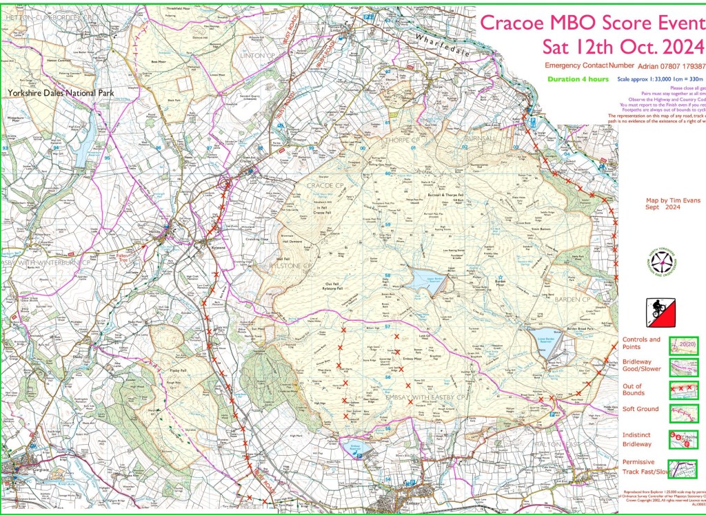
The MapRun download is now ready, please do this before you leave home to avoid relying on a mobile signal in the Dales. It’s at the QR code below or follow this path in MapRun: Select event | UK | north yorkshire | nymbo | summer 24 | cracoe
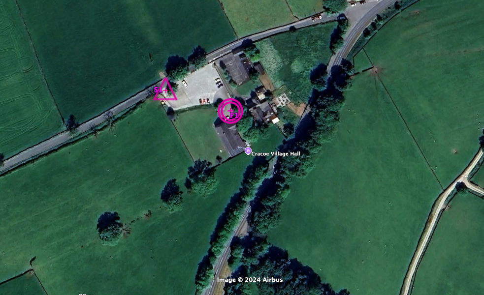
Car parking is at the Village Hall and there should be plenty for all, but please take car when arriving and leaving tro avoid other competitors.
Prize Giving & refreshments afterwards – there will be tea, coffee and juice plus a variety of savoury items (like sausage rolls & scones). Please let us know if you have any dietary/allergy requirements you’d like us to take into account.
It’s our next event on 12th October and it’s the final event of the summer season (before the winter series starts in November). There will be a prize presentation immediately afterwards for the series class winners (UPDATED league positions here – NYMBO League 7 events v2)
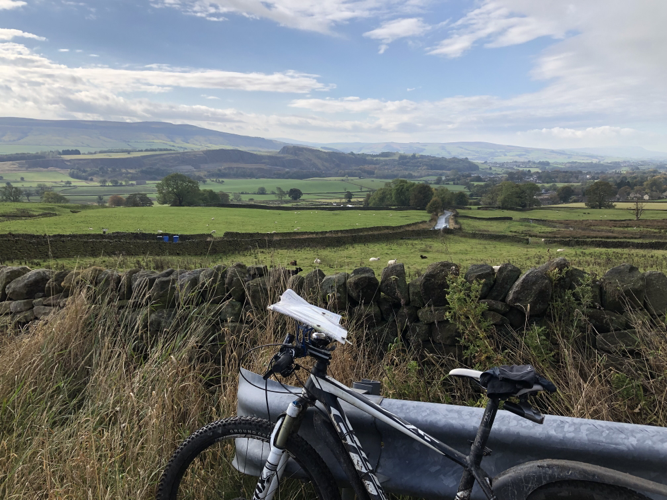
Cracoe is not in Poland – it is in fact in the Yorkshire Dales – to the South West of Grassington. This classy event centre in the village hall is a new venue for NYMBO and allows the event to take in Barden/Embsay Moor and Flasby Fell to the South which have not been in our event areas recently (ever?).
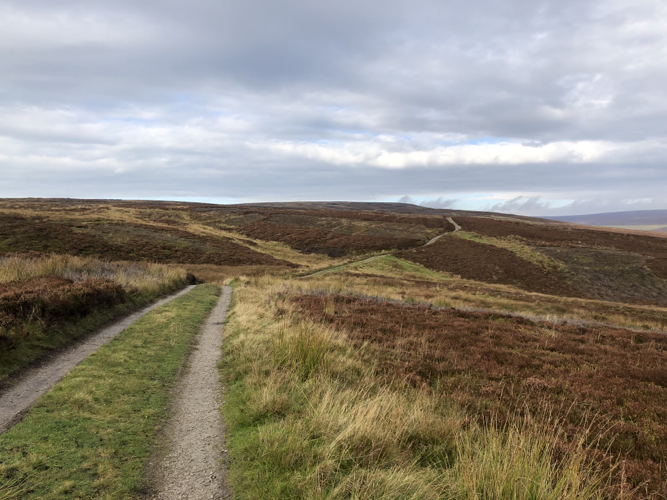
The event will feature a variety of terrain and surfaces, from minor roads, what should still be firm going in pasture, some cracking moorland tracks and a bit of proper (easy) orienteering navigation
There will be loops to suit all tastes with wide open moorland contrasting with the intricate network of rights of way around Cracoe and Hetton. Expect some interesting climbs and swooping descents, and 4 hours to enjoy it all in.
Registration – 9.15 – 10.15 Starts – 9.30 – 10.30
MapRun download an other event details will be posted on the website next week. Here’s the course map: