Thanks to Steve Willis for planning yesterday’s event, here’s his report and the control map:
Thanks to the Dales Bike Centre for hosting our event (and the coffee & cake), Tim Evans for his hard work with the map as well as the 4 gamekeepers for raising no objections to the event taking place and allowing us to use a number of their private estate tracks.
Using Maprun instead of SportIdent worked well for most riders and hopefully it will improve in the near future as it saves so much time putting out and collecting the controls as well as removing the problem of controls going missing. The main problem is not being able to load an OS map on the Maprun App so there were slight (ie 50m) differences in the locations of 4 controls. Hopefully it didn’t spoil anyone’s ride.
I thoroughly enjoyed checking all of the control sites over the previous 2 months as it’s a cracking area with stunning views and great trails. It was reassuring to see that the leading 4 riders all went to different first controls – and surprising that winner’s first control was at the top of Fremington Edge!! Most riders also visited most of the controls on the excellent Swale Trail which, despite the gates, is so enjoyable as it is fairly flat.
Congratulations to the Gents winners Harry Kingston M21 400;Stuart Pigg M40 380: Conrad Ellison M50 365: Chris Swift M60 340; David Day M70 325; Ladies – Angela Brand Barker W60 275; Mixed – Dean & Molly Ralphson X40 330; Generation – Jeffrey & Laura Barber 320: John Hollows Ebike 380. Final congratulations to the 5 riders who won the Spot prizes which were at Controls 1, 2, 3, 17 & 21
I hope you can all make it to the final league event of the season at Kildale on Saturday 2nd October. Please stay afterwards when the prizes will be presented to the League winners.
We will be running a series of Winter events again starting in November. Please contact Tim Evans if you would like to plan one in your area from your local pub!
Hope to see you at another NYMBO event soon
Steve Willis
Course Planner
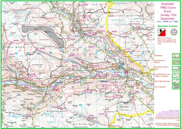
Swlaedale control map (click on the map for the pdf version)

Thanks Steve for producing a different course to previous events which clearly made the riders think about their routes. If the start PIN was published after the event we would be able to look at others’ routes for comparison [these can be found on the MapRun Results website > leader board > swaledale2021 which brings up all the results]. Click on any individual’s track to see their route when PIN is inputted. There are a few competitors who are shown in Steve’s results spreadsheet but not shown on MapRun. If you have not loaded your result onto MapRun yet you need to save your Strava or Garmin track as a GPX file & load it onto MapRun console using menu button, top left
Hi Dave the PIN is 1171, there were 3 who had a maprun fail and it appears that if you use MapRun G it doesn’t show your course , my plan it to place links to these on the website so all can see the routes Cheers Tim
Hi Tim
I used MapRun G on my Garmin 530, I uploaded it from there to MapRun at the event, you need Garmin Connect on your phone, and give MapRun6 permission to access your results from Garmin Connect.
In MapRun6 on your phone select “Show Results” then Get track from Garmin, select the track and the result will be updated.
It saves the result as a run in Garmin, I have Garmin so it uploads automatically to Strava, you have to change it to a ride, before I could do this my son saw the Strava run and was astounded that I had done 26+ mile with 4000+ feet of climbing in 4 hours (if only)
Steve, thanks for this , we will add to the instructions for future ones as it is great to be able to see others routes