Full report and detailed results to follow after Sunday’s event, but here are today’s scores:
Full report and detailed results to follow after Sunday’s event, but here are today’s scores:
The MapRun course downloads are available for this weekend, use the QR codes below, or open MapRun and follow the path:
select event | UK | North Yorkshire | NYMBO | Summer 24
The files are:
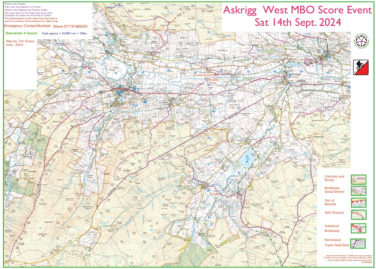
Askrigg 24 West (Saturday)
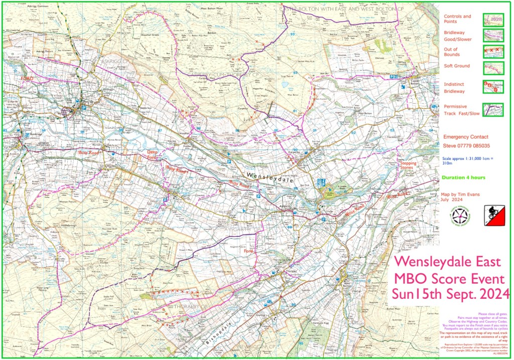
Askrigg 24 East (Sunday)
Please make sure to upload the right file!!
Camping note: there is a narrow gate into the field so anyone towing a caravan or bringing a large motorhome should turn into the wider gate opposite to turn round then drive straight across the road. Camping at the top edge of the field. Day parking to the left
Start & finish locations are shown in the photo, and there’s also a picture showing the campsite location relative to the Brewery.
All other details in the previous 2 posts! See you tomorrow! (Any problems, please message)
UPDATE: Steve’s been out checking the fords this afternoon and as you can see from these photos they are fine for bikes.

 MapRunLink QR Code – Askrigg 24 West
 MapRunLink QR Code – Askrigg 24 East
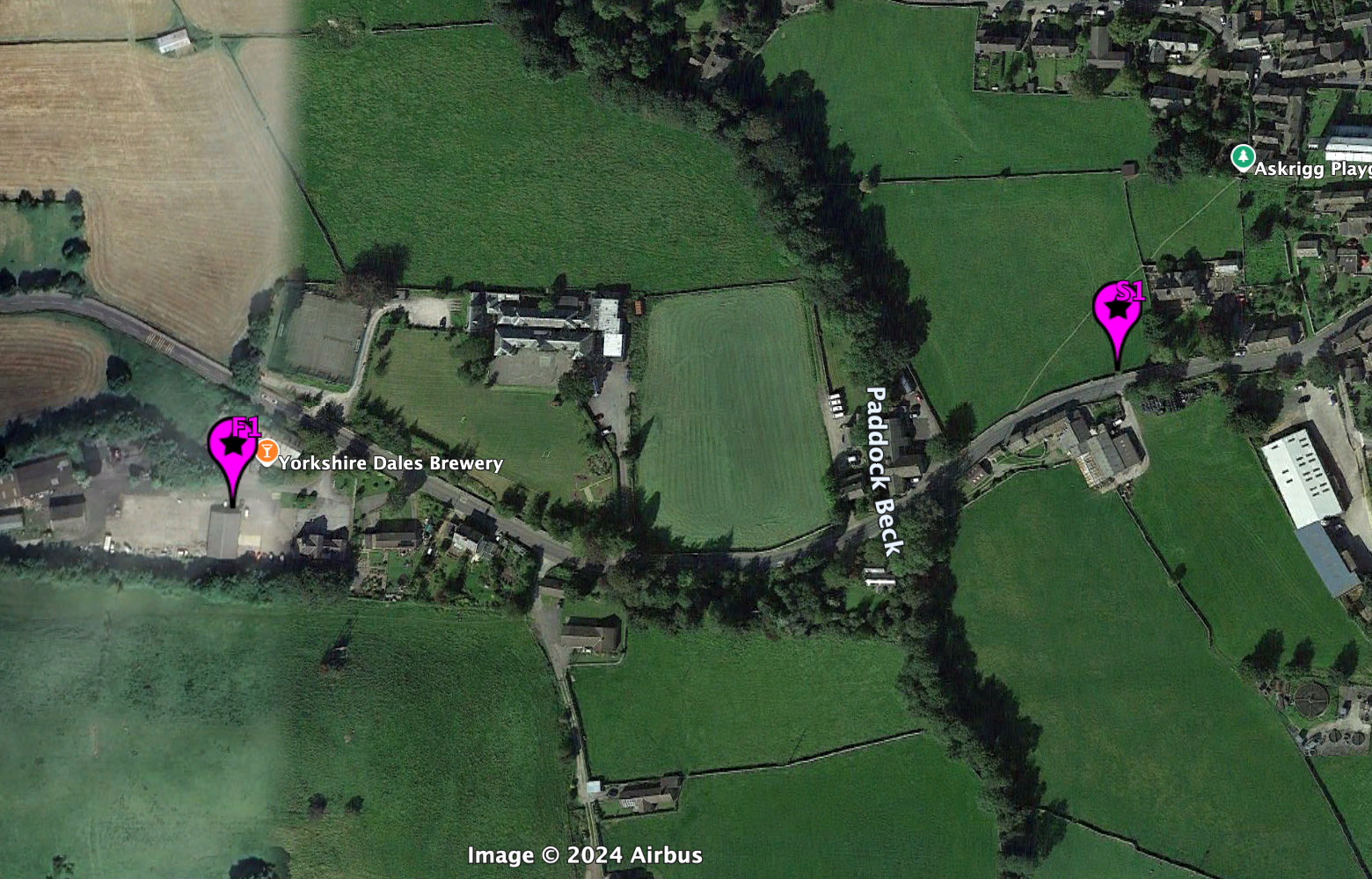 Campsite
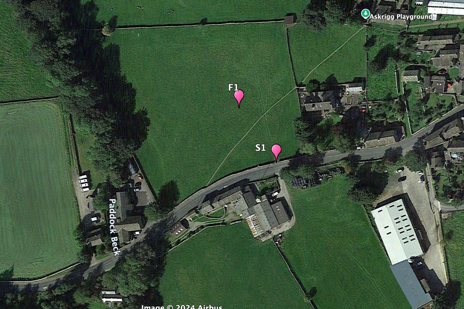 Start Finish locations
Here are the course maps for Saturday and Sunday. Still plenty of time to book – check the previous post here for the online booking links and the camping booking form.
MapRun download, and start/finish locations will be published here later in the week.
NOTE: both events are 4 hours (course maps now updated) 😀
Get in touch if you have any questions. We look forward to seeing you next weekend!
The PDF a files are higher quality downloads than the images below.
It’s just a fortnight until our 2 day MBO event based at Askrigg Camping on Saturday 14th and Sunday 15th September.
IMPORTANT ENTRY NOTE: When you pay for your entry on WorldPay, make sure to click the link to return to the BMBO site as this ensures your registration is confirmed. If you get a WorldPay confirmation but can’t see yourself on the BMBO start list, please get in touch!
Saturday starts are between 1200-1300 and Sunday 1000-1100.
Camping: Please fill out the form below to reserve a camping pitch for one or both nights (£8 per adult). The site has water and toilets and is close to the brewery and village pubs. There will be a generator with sockets for riders to recharge their phones or ebike batteries.
Steve has finished checking the bridleways and controls on Maprun for both days. It’s a beautiful area with stunning views and a variety of excellent and tough tracks. Plenty of hills which are even tougher into the prevailing westerly wind and plenty of gates which all need closing! Hopefully the tracks will stay as dry for the next fortnight especially the fords which will be assessed the day before.
We have got permission to ride a number of private tracks each day but please don’t ride them beforehand when the blank maps are posted online.
Free refreshments when you finish each day and prizes for the overall winners in each class (of 3 riders or more)
Don’t forget to enter by next weekend to get a 25% discount and download the Maprun files when they are announced. Hope to see you there!!
Also, the league results after 5 events can be found here: NYMBO League 5 events
 Carperby Moor
The updated results from Monday can be found here – please notify any changes or corrections by Friday. Note that where Tim has added any missing controls, these are shown first in the splits and have a zero time.
52 of you rode on Monday enjoying the fine weather and the dry conditions. I really enjoyed planning the event and it sounds like it was even drier than when I rode. Although I did remove the worst nettles from the course to save your legs. My plan was to make it hard to clear up and Andy Conn’s winning score of 485 meant the plan worked. Interestingly, Sheila Pearce second place overall and first e-bike with 465 points rode 9km less than Andy’s 67km. Her and Mark seemed to have much more efficient route choices but winner of the points per kilometre was Steve Willis with 8.4 points/km Andy Conn was 7.2. The vast majority of you started with the control in the south east corner and went roughly anti-clockwise. Other category winners were, M40 Martin Edwards with 459 points, M60 Paul Dobson with 420 points, Laura and Jeffrey Barber (generation) with 413 points, first Y18 was Nathan Smith also on 413, first MIX was Dave Cowgill and Claire Riley on 412 and first Solo Woman was Angela Brand-Barker on 360 and first M70 was Steve Willis on 370.
Thank you for all the positive comments and I hope you enjoyed the debrief coffee and cake at the shop afterwards. I must apologies for control 4 it was on the wrong clearing and a few of you spotted the error on the control descriptions with no 23 and 2 29s. I enjoyed looking at your routes on maprun especially those who braved the bridleway north of Wath , I think only Conrad stuck to the correct route, I did wonder if via Hovingham would be faster. I understand the field crossing NW of 24 was marked by a tractor during the event (actually as David Day rode it) so apologies to those who had a tough field crossing it was stubble when I rode it.
I thought Terrington Village hall was excellent and thanks to them for their co-operation and they would like us back, sadly there is no pub so not suitable for a winter event. Thanks to Dave Robertson for the website work and emails, and the advice on the area, I took out the NE corner controls as the route was grotty and as Andy showed the area was large enough.
Talking about Winter we are looking to plan 4 x 2 hour events so any of you fancy a go at planning and have a local area with a pub / cafe in mind let me know where and when you will be given lots of help
I hope the magenta marking made the routes easier to spot but any feedback is greatly received.
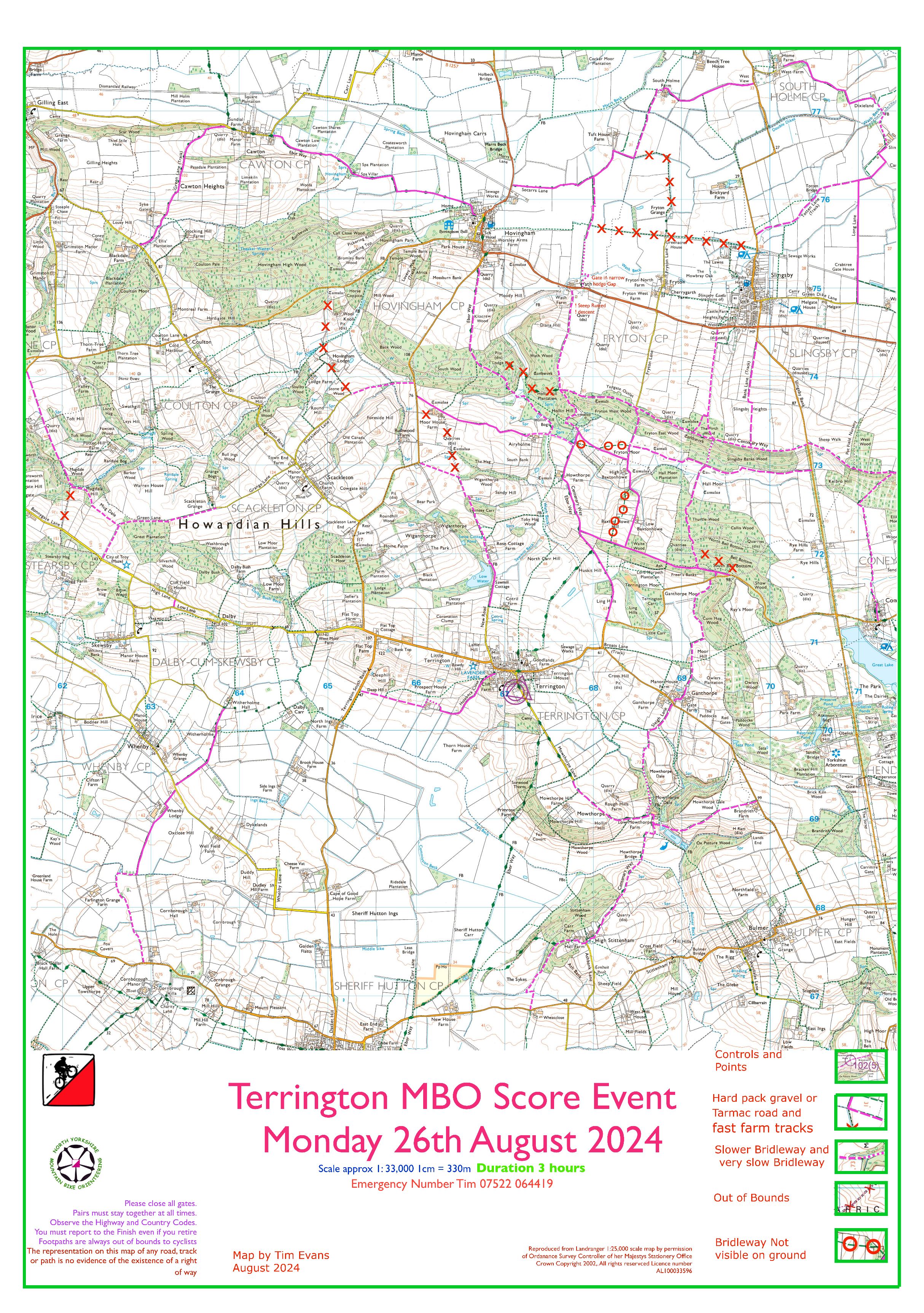
Here’s a copy of the control map and you can check out the individual riders routes on MapRun here (choose ‘show tracks’)
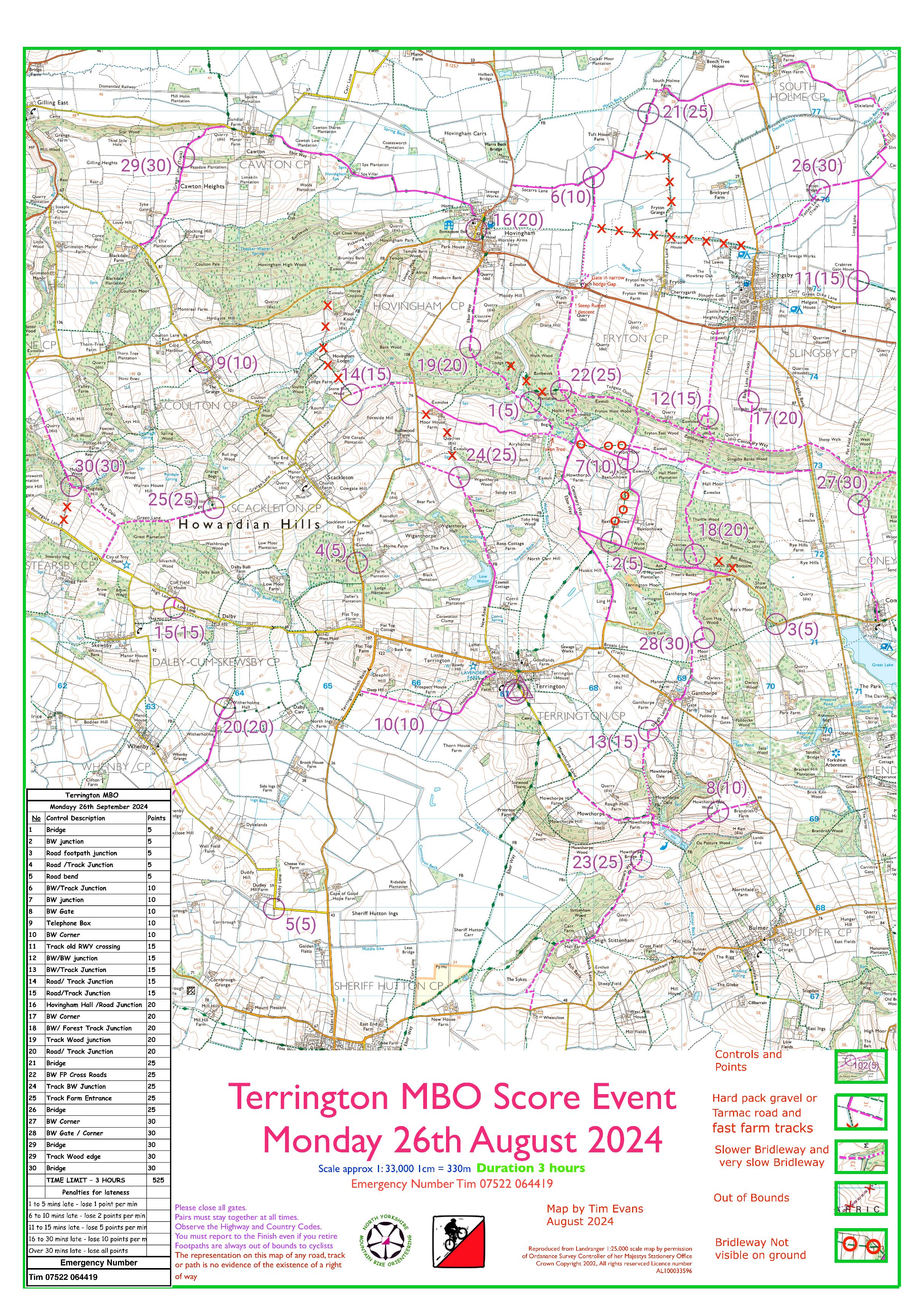
26 August 2024 _ Howardian Hills
Thanks to Tim for planning a challenging course to test all ability levels! Full report to follow shortly, MapRun results are here.
Please report any issues ASAP so Tim can finalise the scores and get a final results table published. Remember, sometimes if you missed controls you can extend the GPS range to pick those up – see instructions here: NYMBO 2024 MapRun published May 2024
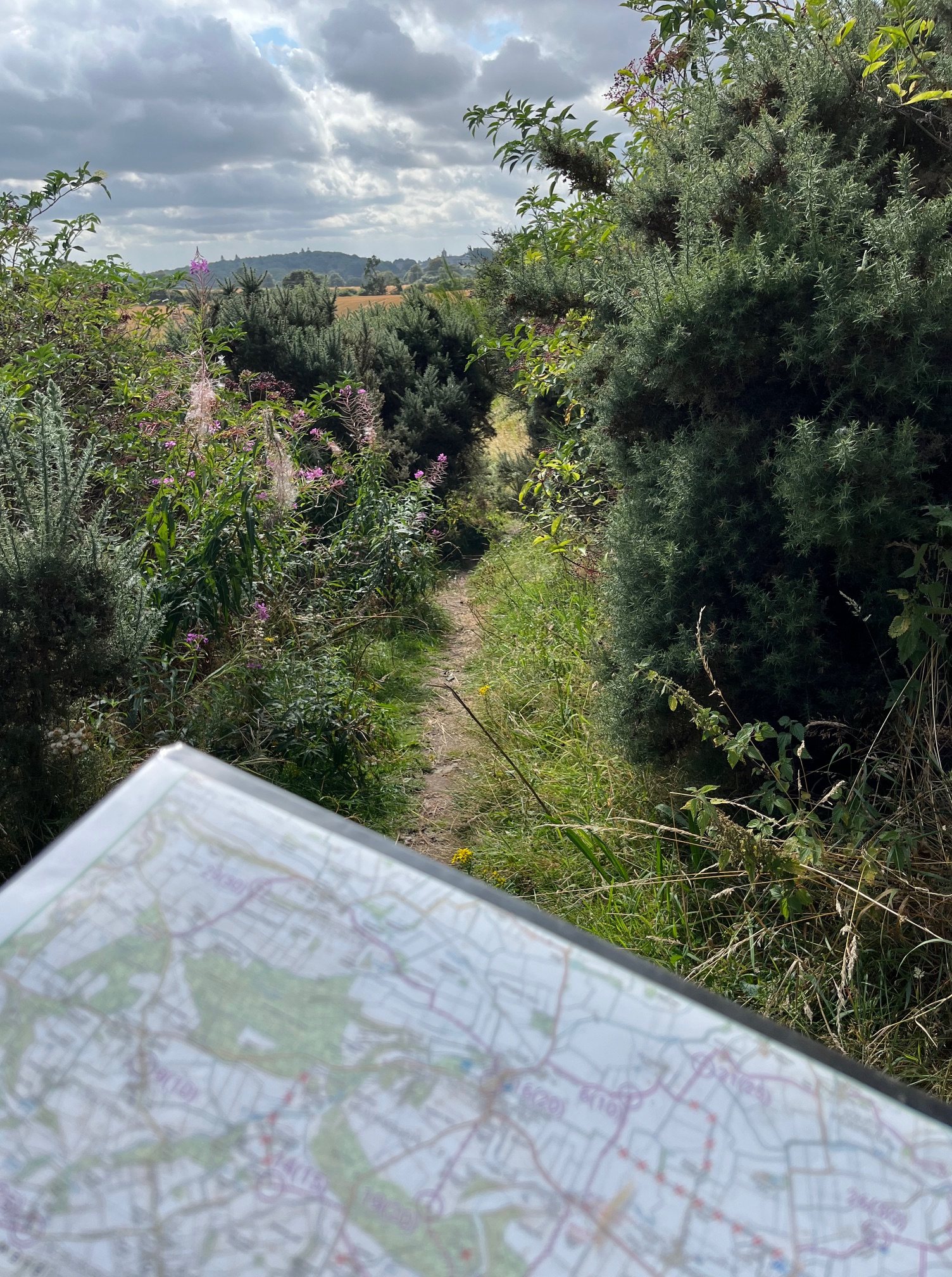
This photo was taken on the descent towards Coneysthorpe and the massive fallen tree!
We’ve already got decent numbers for next Monday, but we can always welcome a few more riders so the online entry deadline has been extended to Saturday.
Enter here (and if you do it by midnight Wednesday there’s 25% off the entry price)
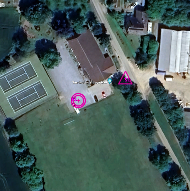
Start finish picture is below and all drivers need to take care entering and leaving the village hall to make sure it is clear of riders starting and finishing please park carefully in the car park.
Maprun now up for downloading, it’s in the usual place or use QR code below to find it.
Parking: The Village Hall has a reasonably large car park but if this is full, the playing field can be used as an overflow parking. If needing to park on the field, please try to keep to the edge of the field adjacent to the tennis court fence, or along the top edge of the field and off the football pitch itself.

It’s 18 days until our Bank Holiday Monday event in the Howardian Hills (26th August), so now is agood time to study the course map and get your online entry in!
Tim has planned a interesting course for you in the Howardian Hills starting from the Village Hall in Terrington. He has cycled all the off road roads you will need to use and some you won’t know have to! The riding was mostly really good with only two short sections that you may need to push and these are clearly marked. As there is no White Rose foot event this year we are going for a normal morning start of 09:30-10:30 but if you struggle getting there for then then let us know and we can allow late starts .
Parking at Terrington Village Hall should be straightforward for all, and a 3 hour event should mean everyone finishes in time to beat any holiday traffic.
Here’s the course map pdf 202408 – Terrington Start
 The miserable weather on Sunday gave Tim a chance to finalise the results from the last 2 events:
And it gave John the chance to sort out the league after 4 events too:
NYMBO League 4 events (PDF)

UPDATED RESULTS AND REPORT (10-Jul)
Thanks to all the riders who came along to our July event at Dallowgill
updated results Dallowgill results rev2 table here, and you can check out the MapRun routes for every rider here
Dallowgill planner’s comments
In the early 20th century Leeds Corporation had a plan to build a reservoir in the steep sided valley of South Gill Beck [immediately south of the event centre]; fortunately this never came to fruition or the Dallowgill bike O may have looked different!
We were grateful to the Delta Trust Academy for the excellent facilities at the outdoor education centre, originally built as Dallowgill School and to Lottie’s Catering – normally found at Hell Wath football field, Ripon. If you did not take up the £2.50 voucher available to all riders you missed a treat!
A geek at the map before the event would have identified the possibility of the W loop into Nidderdale with a teaser of will it go into the Ashfold Side mining valley? [No controls there this time]. Once into Nidderdale the BW E of Gouthwaite reservoir would have to be completed. All but 3 riders who took this option sensibly went down the BW into Bouthwaite & up the tarmac N & E of Pateley Bridge. Apologies for those who took the clockwise route for not indicating on the map the severity of the drainage channels across the steep road down NW from #18. Those who went across the moors were rewarded with fantastic views in all directions thanks to the weather forecast being much better that indicated. Commiserations to Dave Goulding who lost his map somewhere near #16 & had to use googlemaps to find his way back to the finish, which he managed with seconds to spare.
The route through the fields from #5 to #20 was grassy & gated, the wise riders avoided #5 & just dipped in & out from the road to #20.There were enough controls E of the start to make decisions tricky on what to leave out & what order to choose. I made a late map correction to the BW E of #13 based on info received about height of vegetation but then some kind person slashed it down before our event so all was well.
Overall winner with 487 was M40 Mark Chryssanthou, 2nd was M50 Peter Pawlik on 436 only just ahead of M60 Tony Brand Barker on 434. Angela BB was 1st lady with 403 ahead of Claire Riley in the MIX50 class on 398, Jemima Parker & Jo Anderson W50 next on 285. Only 1 GEN team, Michael & Daisy scored 346 but could not stay as Daisy had to go to work [it’s a hard life!] Unusually there was an Ebike tie – Keith Foster & Stephen Morriss [the latter treating his wife to a birthday weekend away in the campervan, no expense spared] scored 395. Based on points/km the most cunning rider was Steve Willis who achieved 9.5, ladies category had Angela at 8.67 & Jemima at 8.66; look & learn from their routes.
David Day


