Our next event is on April 1st (this is not an April Fool!) – Tony has done an excellent preparing for this event, so there are comprehensive event details below.
This event will be using manual entry (hopefully online entry will be working for the following event) so please reserve your map and advance food order here, and then pay by bank transfer or with the correct cash on the day. Entry Form
Parking – There is good parking at the Airedale Heifer BD20 5LY which is the start/finish. However the pub gets busy at lunchtime and if you are not intending to eat at the pub and are likely to finish after 1230 please park on the road outside the pub. This is quite busy, but is wide and has extensive car spaces on the North side of the road. Take care when crossing!
Toilets – there are toilets in the pub which should be open from just before 9.00. Please don’t wear muddy shoes/boots in the pub.
Food – the pub has an extensive menu (see below) There is no need to order food in advance, but if you let me know when registering that you intend to eat, I will let Susie know.
MapRun – if you’re using the MapRun app on your phone make sure it’s MapRun6, and don’t forget to download the event in advance (folder is UK:North Yorkshire:NYMBO: RIddlesden) – updated FAQ here.The MapRun map is the competition map but the resolution is not as good as the printed map, although all the controls are in the right place. They have all been checked for accuracy, but if you go past them at very high speed they may not register.
Start/Finish – You can register from 0850-1000 and start from 0915-1015. The time limit is 3 hours with the usual penalties. There are no pre-assigned start times; first come, first served. At the start you will get a printed map with all the controls and descriptions on. The start is where the pub tarmac joins the main road, but as we have set the control range at 30m, it is likely to start you as soon as you tap ‘go to start’. So, when told to start, and not before, tap ‘Go To Start’ on MapRun and it should bleep when the GPS finds you at the start. You will be timed from that point. The finish is in the car park. I cannot see why anyone would cycle back past the start until they want to finish, but if you do MapRun is quite likely to end your run. We will try to make adjustments at the end if anything goes wrong. A Strava track of your route would be good evidence and can be uploaded to MapRun manually.
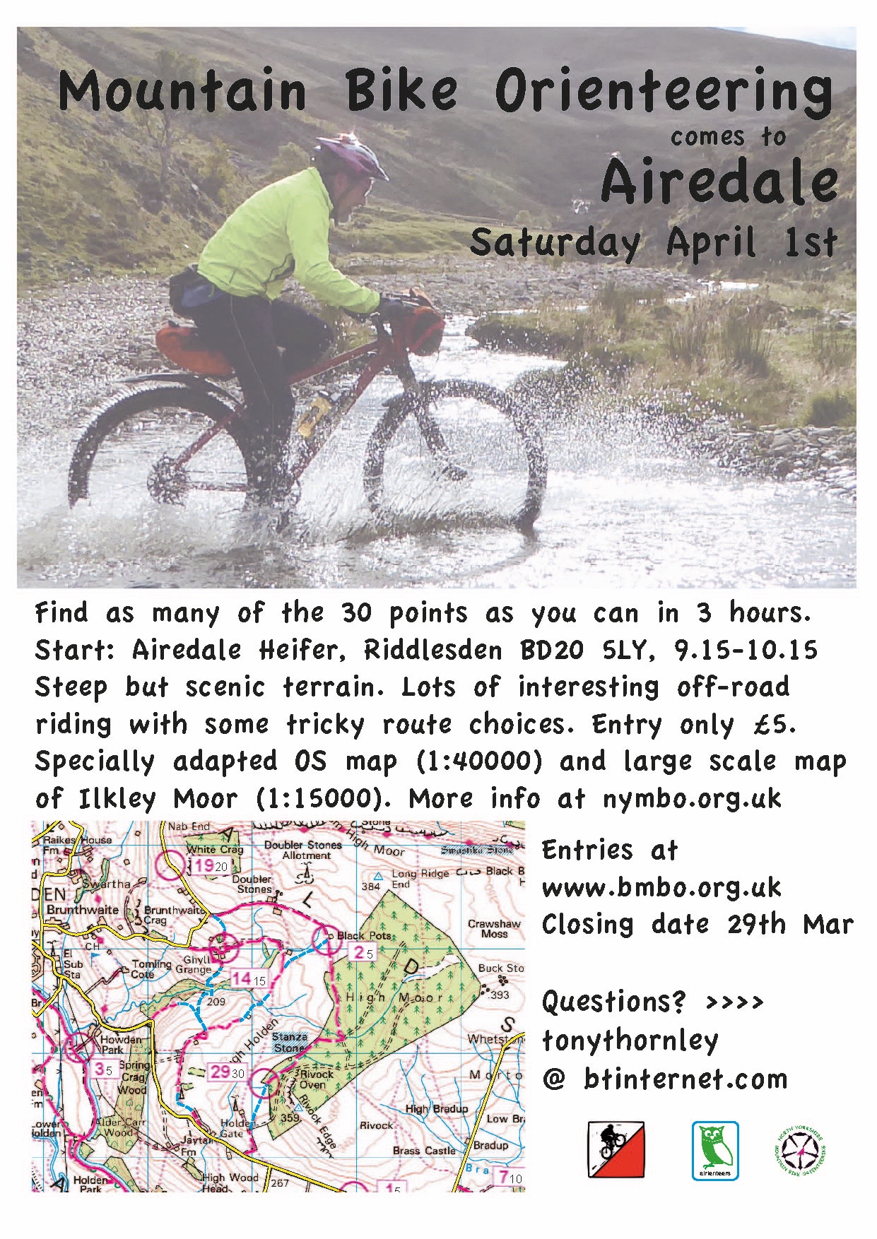
Course map – the blank course maps are below (Full map, Ilkley Moor map). The main map is 1:40000, adapted from the 50000 OS and 290x255mm. It is marked with the usual 30 controls with points values between 5 and 30. Unusually we are also providing a separate, large scale (1:15000) map of Ilkley Moor which those of you who choose to visit the wilds of Wharfedale may find useful.
Safety – this event has more busy roads than the usual NYMBO event. These are clearly shown on the map, with the AIRE valley relief road marked as out of bounds. We urge you to take great care:
• On leaving the start and returning to the finish
• At road junctions.
• On the Leeds-Liverpool canal towpath. There are likely to be many pedestrians and dogs who have priority. Please bring and use a bell.
• If the weather is poor carry/wear a good outer layer. Some controls are 300-400m up on exposed moorland.
You must report to the finish. There is an emergency contact number on the map.
Terrain – It’s hilly. The rideability of the bridleways is mostly ok and is shown on the map – see the legend – but these are very weather and ride dependent. You can go anywhere on Ilkley Moor, but it is boggy in some places and navigation can be tricky. Please give way to any walkers you come across.
Here is Simon’s report for last Saturday’s Hampsthwaite event – thanks to Simon Coiley for organising this one. A little later in posting thank we would usually like, sorry about that!
It was great to see over 50 riders on a chilly but thankfully mainly dry morning at Hampsthwaite Memorial Hall. Even better were the many smiling faces on their return. I do believe some who ventured higher up did get to enjoy some sleet though!
Thank you for the many positive comments at the finish.
I had really enjoyed my pIanning rides on steadily drying bridleways. I still tried to place plenty of points on the local network of roads, just in case the weather didn’t behave, whilst also giving plenty of route options further afield.
Looking at the maprun tracks, there was a good spread of routes in both main
directions from the village. I’m sure you all discovered the deceptive amount of
climbing whichever direction you chose! On this occasion it was Nuno Cerqueira that
triumphed in his ding dong battle with Martin Edwards for overall winter honours with
both now on two victories. Nuno chose a clockwise route around the whole perimeter
of the map only leaving the three controls along the river Nidd near Birstwith and
control 13 at Hartwith.
Congratulations to all the category winners:
M – Nuno Cerqueira – 471 points
W – Claire Riley – 326
MV60 – Steve Collins – 378
Youth – Mieszko Lichtarowisz & James Harrison – 302
Gen – Jeffrey & Laura Barber – 290
Mix – Sally Buckworth & Saul Muldoon – 289
Thanks to Rebecca and the team at the Joiners Arms for the warm welcome and
food afterwards.
Massive thanks to Tim Evans for his help and patience with the mapping and also
manning registration. Big thanks also to Dave Robertson for sorting the entries, food
orders and web postings. We should hopefully have the Bmbo entry system back up
and running for the next event.