Planner’s Comments:
Thanks to all of you for coming and for the kind comments. It was good fun checking out all the bridleways (in the winter of course when at least half were deep in mud) and planning the course. The turnout was almost as good as at Markington, which was pleasing given that Pool is at the south edge of NYMBO’s usual terrain.
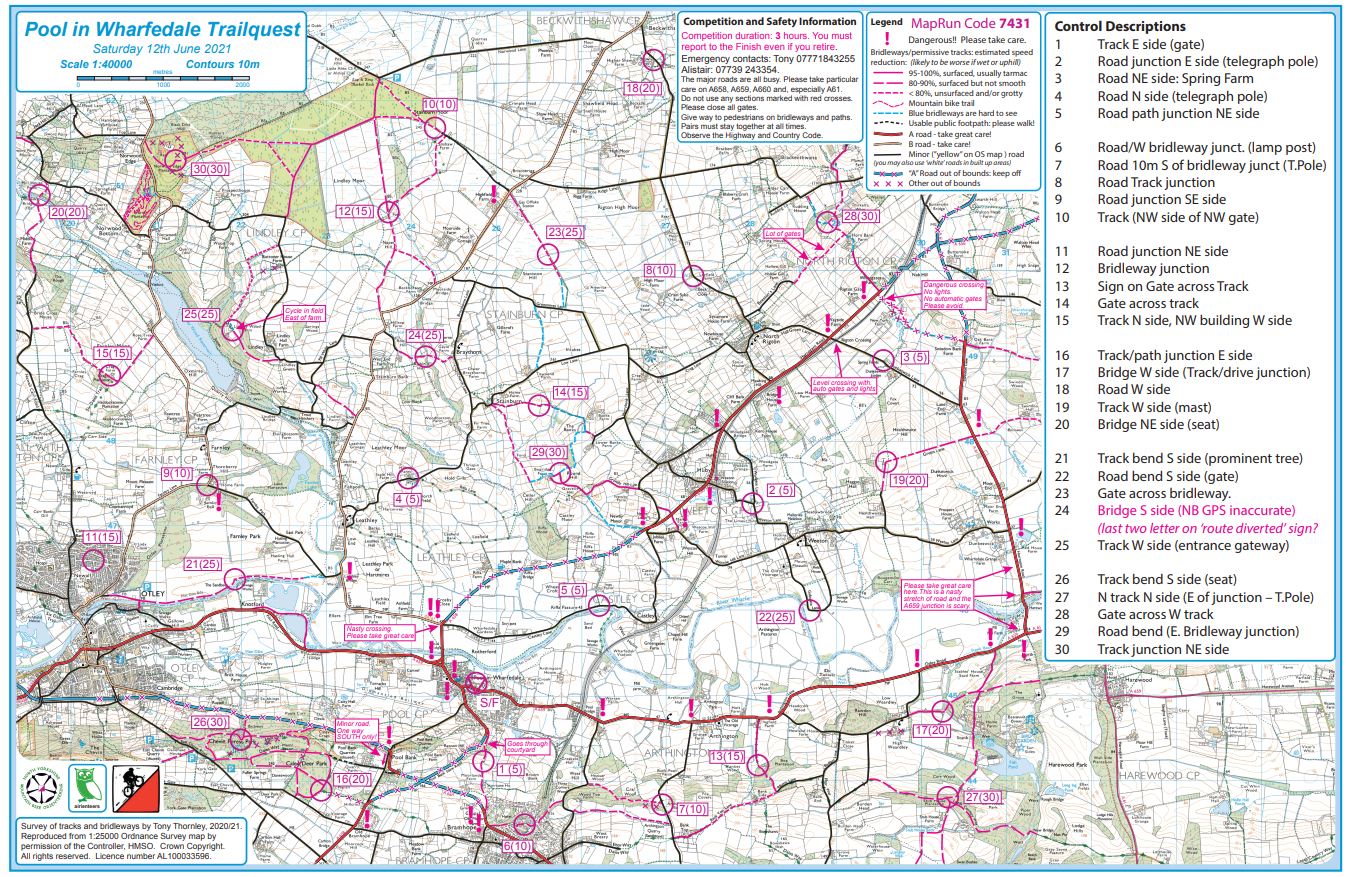
From a quick scan of the routes, there was no consensus about the right order to tackle the controls. Exactly as I had hoped. Most people chose to avoid the north east and many started along the south edge, although the two sites in Danefield were strenuous and a bit harder to locate than most of the others. Ian, Ian and Andy who finished within 7 points of each other at the top used quite different strategies. Ian Nixon did by far the most cycling, but got stuck on almost the only really grotty bridleway in Stainburn Forest and finished up a bit late.
MapRun is by no means perfect but it does reduce the need to find ‘clues’ and involves no hardware in the terrain – although I did put out a couple of tapes at sites where there was no feature, in case MapRun didn’t work there. Most of the MapRun failings in the results were down to human errors, for example failing to start the App or losing a phone. And control 24, which I had failed to get to work twice, was fine for everyone. As the GPS signal seems to vary with weather as well as terrain, it may be that we need to hold our events on nice days? But there were a worrying handful of you whose GPS dropped out during the event, just as mine did at Markington. I wonder if MapRun cannot reconnect easily with a phone on a bike that is moving – on the whole – faster than with a static or slower moving phone? I think, on balance, that MapRun is here to stay for Trailquest type events, but it needs a slightly different approach to planning, and may not do for events in steep wooded terrain on wet days.
My thanks to Quentin Harding for uploading the MapRun files for me, to Tim for map printing, to Steve and Dave for managing the NYMBO website, to Cecily at Pool Memorial Hall and to Alistair Wood for all sorts of help with the event. I was going to put a control in his garden in Leathley but decided that it might be a bit too confusing.
Tony Thornley

Thanks for planning such a great event. Quite a few hidden gems of bridleways that I’d never used although I’m fairly local. MapRunG on my watch worked pretty well for both events – uploading the track afterwards was a little sketchy but overall I think it’s really good.
The headwind on the way in from Castley when I was already late was the only downside!
Thanks for another enjoyable event, Markington was my first use of MapRun6 and user error resulted in my phone sleeping, so I only registered one control, for this event I used MapRunG on my Garmin Edge 520, it worked flawlessly, recording all the controls easily.
I have ridden some of the roads in the area but no tracks, this influenced my route choice and I probably could have picked up a few more points with a different route, but having been up Old Pool Bank on the road bike I wanted to ride it on the MTB (I was younger and faster on the road bike)
The two controls in Danefield were my starting point, for better point scoring missing these two and going straight to number one would have given more time to pick easier controls later.
I also chose the wrong route from 30 to 14, I couldn’t find the easy track round the farm.